|
gm. Stegna, pow. nowodworski, woj. pomorskie
Until 1945 Fürstenwerder (Gotha, Endersch, Schrötter)
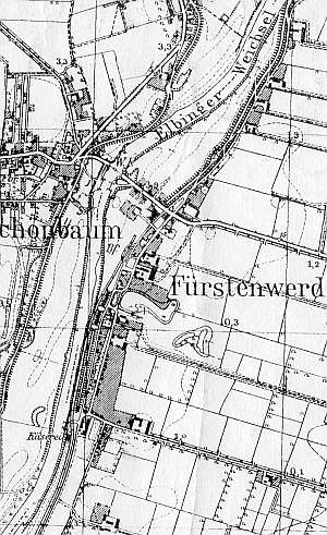
The village was established by Winrich von Kniprode in 1352 under the Chełmno law for 18 colonists. At the time, also a parish church was erected. In 1510, the village had 26 homesteads, including a village leader's farm, a parish priest, and 3 inns. During the following half century, the number of farms and inns (Scottem Krug and Janken Krug) decreased. In 1659, the village was burned by the Swedish army. In 1772, Żuławki had 62 włókas and 17 Mennonite families with 81 persons. The sources from 1776 mentioned the following families: van Bergen, Bruhn, Dridger, Essau, van Riesen, Gruntu, Harder, Claassen, Manteler, Plett, Reimer, Thiesen, Warckentin, and Wiebe. In 1820, the village had 564 residents, including 52 Mennonites. In 1864, the village had 787 residents, 67 houses, and 92 outbuildings. The petition from 1868 from Żuławki was signed by Jacob Dűck, Dawid Heidebrecht, Joann Penner, Hermann Riesen, and Jacob and Joann Wiebe. In 1889, the village had 794 residents, including 62 Mennonites, 19 landowners, and 76 houses. Village layout - a flood bank Waldhufendorf village located on the eastern bank of the Elbląg Vistula. The cultural landscape has been relatively well preserved. The documentation from 1979 mentioned 29 wooden houses, including 2 from the 18th century, 6 from the first half of the 19th century, 13 form the 2nd half of the 19th century, and 8 from the beginning of the 20th century, 5 Dutch homesteads, and 3 masonry houses. The Gothic church was demolished in 1839, and replaced by the current church in 1840-41.
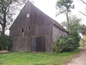
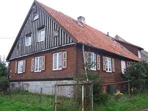 No. 80 is a house from a longitudinal Dutch homestead.
Farming buildings (higher, modified) are located on the eastern side. The
homestead is located in the southern section of the village, on the
eastern side of the road parallel to the main route, facing it with its
gable. The building was erected in the 3rd quarter of the 19th century and
has a brick underpinning, a log structure with corners covered by boards
imitating pilaster, a vertically boarded gable, a rafter - collar beam
roof structure, a small pent-roofed attic room in the southern roof slope,
and pantile roofing. The interior has a 2-bay layout with a wider western
bay, the large room in the southwestern corner and a black kitchen in the
large room bay. The western elevation has 3 axes, two-level gable with 4
axes in the bottom section, two windows enclosed by triangular skylights,
and a small semicircular window above. The southern elevation
(symmetrical) has 7 axes and a centrally located entrance with a
porch. No. 80 is a house from a longitudinal Dutch homestead.
Farming buildings (higher, modified) are located on the eastern side. The
homestead is located in the southern section of the village, on the
eastern side of the road parallel to the main route, facing it with its
gable. The building was erected in the 3rd quarter of the 19th century and
has a brick underpinning, a log structure with corners covered by boards
imitating pilaster, a vertically boarded gable, a rafter - collar beam
roof structure, a small pent-roofed attic room in the southern roof slope,
and pantile roofing. The interior has a 2-bay layout with a wider western
bay, the large room in the southwestern corner and a black kitchen in the
large room bay. The western elevation has 3 axes, two-level gable with 4
axes in the bottom section, two windows enclosed by triangular skylights,
and a small semicircular window above. The southern elevation
(symmetrical) has 7 axes and a centrally located entrance with a
porch.
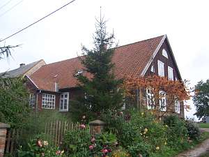 No. 79 is a house from a longitudinal Dutch homestead.
Farming buildings (higher, modified) are located on the eastern side and
are separated by a fire wall. The house is located in the southern section
of the village, on the eastern side of the road parallel to the main
route, facing it with its ridge. The building was erected in 1860 for an
owner with the initials H.F. It has a brick underpinning, a log structure
with boarded corners, a vertically boarded gable, a rafter - collar beam
roof structure, and pantile roofing. The interior has a 2-bay layout with
a wider western bay, the large room in the southwestern corner and a black
kitchen in the large room bay. The southern elevation has 3 axes, a
two-level gable with 4 axes in the bottom section, two windows enclosed by
triangular skylights, and a small semicircular window above. The western
elevation has 6 axes with an entrance located in the 3rd axis from the
east. No. 79 is a house from a longitudinal Dutch homestead.
Farming buildings (higher, modified) are located on the eastern side and
are separated by a fire wall. The house is located in the southern section
of the village, on the eastern side of the road parallel to the main
route, facing it with its ridge. The building was erected in 1860 for an
owner with the initials H.F. It has a brick underpinning, a log structure
with boarded corners, a vertically boarded gable, a rafter - collar beam
roof structure, and pantile roofing. The interior has a 2-bay layout with
a wider western bay, the large room in the southwestern corner and a black
kitchen in the large room bay. The southern elevation has 3 axes, a
two-level gable with 4 axes in the bottom section, two windows enclosed by
triangular skylights, and a small semicircular window above. The western
elevation has 6 axes with an entrance located in the 3rd axis from the
east.
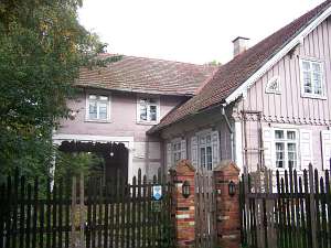 No. 75 is an arcaded house erected in 1859 by a carpenter
with the initials C.C. It is situated in the eastern section of the
village, on the eastern side of the road, facing it with its ridge. The
house has a log structure with quoins covered by boards imitating
pilaster, vertically boarded gables, a brick underpinning, an arcade
supported by 6 posts and half-timbered walls (west side), a hipped roof
arcade (east side) supported by 8 posts, a queen post - purlin roof
structure, and pantile roofing. The interior has a 2-bay layout with wider
western bay, the large room in the southwestern corner, a black kitchen in
the large room bay, a Z-shaped, bipartite hallway, which separates the
farming section and has 4 doors to a utility hallway. The southern gable
elevation has 3 axes and a 2-level gable with 5 axes in the lower level,
three windows enclosed by quarter circular skylights, and a semicircular
window above. The western elevation has 7 axes with a 2-axial extension
above an arcade in the 3 central axes and a centrally located
entrance. No. 75 is an arcaded house erected in 1859 by a carpenter
with the initials C.C. It is situated in the eastern section of the
village, on the eastern side of the road, facing it with its ridge. The
house has a log structure with quoins covered by boards imitating
pilaster, vertically boarded gables, a brick underpinning, an arcade
supported by 6 posts and half-timbered walls (west side), a hipped roof
arcade (east side) supported by 8 posts, a queen post - purlin roof
structure, and pantile roofing. The interior has a 2-bay layout with wider
western bay, the large room in the southwestern corner, a black kitchen in
the large room bay, a Z-shaped, bipartite hallway, which separates the
farming section and has 4 doors to a utility hallway. The southern gable
elevation has 3 axes and a 2-level gable with 5 axes in the lower level,
three windows enclosed by quarter circular skylights, and a semicircular
window above. The western elevation has 7 axes with a 2-axial extension
above an arcade in the 3 central axes and a centrally located
entrance.
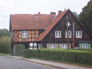
 No. 76 is a granary dating from the end of the 18th
century situated in the northwestern corner of the homestead. It has a
vertically boarded half-timbered structure, 2 stories, and a
double-pitched, ceramic roof. No. 76 is a granary dating from the end of the 18th
century situated in the northwestern corner of the homestead. It has a
vertically boarded half-timbered structure, 2 stories, and a
double-pitched, ceramic roof.
 No. 43 is an arcaded house erected
in 1848 for an owner with the initials F.R. It is situated in the village
center, on the eastern side of the road, it has a log structure with
quoins covered by boards imitating Tuscan pilaster, vertically boarded
gables, a brick underpinning, a half-timbered extension (west side)
supported by 6 pillars and half-timbered walls (partially disassembled),
a rafter - collar beam roof structure, and pantile roofing. The
building has a 2-bay layout with wider western bay, the large room in the
southwestern corner, a black kitchen in the large room bay, and an
L-shaped, bipartite hallway, which separates the farming section from the
residential one. The interior has been heavily modified. The southern
gable elevation has 3 axes, a two-level gable with 4 axes in the lower
level, two windows enclosed by triangular skylights, and a semicircular
window above. The western elevation has 7 axes with a 2-axial extension
above an arcade in the 3 central axes and a centrally located
entrance. No. 43 is an arcaded house erected
in 1848 for an owner with the initials F.R. It is situated in the village
center, on the eastern side of the road, it has a log structure with
quoins covered by boards imitating Tuscan pilaster, vertically boarded
gables, a brick underpinning, a half-timbered extension (west side)
supported by 6 pillars and half-timbered walls (partially disassembled),
a rafter - collar beam roof structure, and pantile roofing. The
building has a 2-bay layout with wider western bay, the large room in the
southwestern corner, a black kitchen in the large room bay, and an
L-shaped, bipartite hallway, which separates the farming section from the
residential one. The interior has been heavily modified. The southern
gable elevation has 3 axes, a two-level gable with 4 axes in the lower
level, two windows enclosed by triangular skylights, and a semicircular
window above. The western elevation has 7 axes with a 2-axial extension
above an arcade in the 3 central axes and a centrally located
entrance.
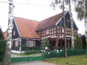
 No. 32-33 is an arcaded house erected in 1797 (modified
and renovated in 1851) for Cornelius Froese by Jakob Dick. It is situated
in the northern section of the village, on the eastern side of the road.
The building has a log structure with quoins covered by boards imitating
pilaster, vertically boarded gables, a brick underpinning, a half-timbered
arcade supported by 6 Tuscan columns and half-timbered walls, a
rafter-collar beam roof structure reinforced with queen posts, and pantile
roofing. The interior has a 2-bay layout with similar bays. The large room
is located in the southwestern corner and a black kitchen in the large
room bay. Originally, the building had a bipartite, L-shaped hallway,
which separated the northern section. The southern gable elevation has 3
axes, a two-level gable with 3 axes at the lower level and a semicircular
window above. The western elevation has 7 axes with a 2-axial extension
above an arcade in the 3 central axes and a centrally located
entrance. No. 32-33 is an arcaded house erected in 1797 (modified
and renovated in 1851) for Cornelius Froese by Jakob Dick. It is situated
in the northern section of the village, on the eastern side of the road.
The building has a log structure with quoins covered by boards imitating
pilaster, vertically boarded gables, a brick underpinning, a half-timbered
arcade supported by 6 Tuscan columns and half-timbered walls, a
rafter-collar beam roof structure reinforced with queen posts, and pantile
roofing. The interior has a 2-bay layout with similar bays. The large room
is located in the southwestern corner and a black kitchen in the large
room bay. Originally, the building had a bipartite, L-shaped hallway,
which separated the northern section. The southern gable elevation has 3
axes, a two-level gable with 3 axes at the lower level and a semicircular
window above. The western elevation has 7 axes with a 2-axial extension
above an arcade in the 3 central axes and a centrally located
entrance.
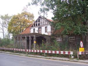
No. 4 is a longitudinal Dutch homestead situated in the
southern section of the village, on the eastern side of the flood bank
road, facing it with its ridge. A cowshed is much higher and dates from
the beginning of the 20th century. The house was erected in 1839 by H.
Dick for W. Staats and has a plastered log structure and a rafter - collar
beam roof structure covered by asbestos tiles.
No. 64 is an
arcaded house built in 1721 by Peter Loewen for Izaak Schultz with an
arcade added in 1803. It is situated in the eastern section of the
village, on the northern side of the local road. It has a corner-notched
log structure with quoins covered by boards imitating pilaster, vertically
boarded gables, a half-timbered arcade (south side) supported by 6 frontal
and 2 side posts and narrow, half-timbered walls, a hipped roof arcade
(north side) supported by 5 posts, a rafter - collar beam roof structure,
and a pantile roof. The building has a 2-bay layout with a wider western
bay, the large room in the southeastern corner, a black kitchen in
the large room bay, an L-shaped (divided later) hallway separating the
farming section with 3 doors in the farming hallway. The gable (southern)
elevation has 3 axes and a 2-level gable with 3 axes at the bottom and 1
axis above. The eastern elevation has 7 axes with a 2-axial extension and
an arcade in the 3 central axes and a centrally located
entrance.
 No. 6 is an arcaded house situated in the northern
section of the village, on the eastern side of the road. It was erected at
the end of the 18th century (rebuilt in 1825) by a carpenter with the
initials A.K. for Peter Epp. The building has a log structure with quoins
covered by boards imitating pilaster, vertically boarded gables, a brick
underpinning, a half-timbered arcade (west side) supported by 6 posts and
half-timbered walls, a vertically boarded gable, a rafter - collar beam
roof structure, and pantile roofing. The interior has a 2-bay layout with
wider western bay, the large room in the southwestern corner, a black
kitchen in the large room bay, and an L-shaped, bipartite hallway, which
separates the farming section from the residential one. The utility
hallway has 4 doors. The southern gable elevation has 3 axes and a 2-level
gable with 3 axes at the lower level and a semicircular window above. The
western elevation has 6 axes with an entrance in the 3rd axis from
the north and an arcade in axes 2-4 from the north. No. 6 is an arcaded house situated in the northern
section of the village, on the eastern side of the road. It was erected at
the end of the 18th century (rebuilt in 1825) by a carpenter with the
initials A.K. for Peter Epp. The building has a log structure with quoins
covered by boards imitating pilaster, vertically boarded gables, a brick
underpinning, a half-timbered arcade (west side) supported by 6 posts and
half-timbered walls, a vertically boarded gable, a rafter - collar beam
roof structure, and pantile roofing. The interior has a 2-bay layout with
wider western bay, the large room in the southwestern corner, a black
kitchen in the large room bay, and an L-shaped, bipartite hallway, which
separates the farming section from the residential one. The utility
hallway has 4 doors. The southern gable elevation has 3 axes and a 2-level
gable with 3 axes at the lower level and a semicircular window above. The
western elevation has 6 axes with an entrance in the 3rd axis from
the north and an arcade in axes 2-4 from the north.
Schmid, s.48-55; Lipińska, t. III, poz. 259; AG IV, BF.
|
)