|
gm. Markusy, pow. elbląski, woj. warmińsko - mazurskie
Until 1945 Wengeln, Reichhorst TK (Endersch, Schrőtter),
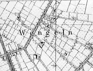
The village of Węgle was founded in 1557 by Dutch settlers, while Żukowo, in 1631. Currently these two settlements form a single village. The sources from 1776 mentioned the following families: Albrecht, Dau, Ens, Friesen, Froes, Froesen, Funck, Goertzen, Harms, Jantzen, Lambert, Pauls, and Quiring. The sources from the 19th century mention the following names: Peter Paulus, Dawid Kuapp, Melchior Dau, and Kornelius Froese. In 1820, the village had 95 residents, including 64 Mennonites. Village layout - a single homestead village on terpy and a flood bank row village in the eastern section of Żukowo. The cultural landscape is in decline. In 1986, 11 out of original 30 homesteads were still present. Currently, almost all of them have disappeared. Several modified homesteads have survived by a flood bank of lake Drużno and in colonies. A field layout, a system of drainage canals, and terpy are detectable. The Mennonite cemetery has been severely devastated.
No. 10 is a house from an angular Dutch homestead situated to the south of the Węgle - Żurawiec road, in the colony. The building dates from the end of the 18th century and until 1945 belonged to Dawid Kuapp called Grundstarken. Originally, it was an arcaded house with a plastered log structure (the eastern wall was built later), a boarded gable, a concreted foundation, and a wooden queen post - two-collar beam roof structure. The interior has a 2-bay layout with the large room in the southwestern corner, a black kitchen in the large room bay, two rooms separated by a corridor to the cowshed, and a staircase leading to the attic on the northern side of a divided (later) hallway. The gable elevation has 3 axes and a 2-level gable with two square-like windows enclosed by rhomboidal skylights (lower section) and a single window above. The frontal elevation has 6 axes and an entrance in the 3rd axis from the north.
A cowshed and barns have been taken down.
No. 14 is a house from a longitudinal Dutch homestead situated in the southern section of Żukowo, by the lake Drużno flood bank. It was erected in the 1st quarter of the 19th century. The building has a plastered log structure with quoins covered by boards, a boarded gable, a brick foundation, and a rafter - two-collar beam roof structure. The interior has a 2-bay layout with wider western bay, the large room in the southwestern corner, a black kitchen in the large room bay, and two separate L-shaped hallways. The gable elevation has 2 axes and a single-axial gable. The frontal elevation has 5 axes, an entrance in the 2nd axis from the north, between narrow windows, and a bullseye.
 No. 15 is a house from an angular Dutch homestead situated by the lake Drużno flood bank, facing it with its ridge. It was erected at the end of the 18th century and until 1945 belonged to A. Kunger. The building has a plastered log structure, a boarded gable, a stone/brick foundation, a rafter - two-collar beam roof structure, and skylights in both roof slopes. The interior has a 2-bay layout with a wider western bay, the large room in the northwestern corner , a black kitchen in the large room bay, and a bipartite hallway, which separates the farming section. The gable elevation has 3 axes, a two-level gable with 2 axes at the lower level, and a single axis above. The frontal elevation has 5 axes with an entrance in the 2nd axis from the south. No. 15 is a house from an angular Dutch homestead situated by the lake Drużno flood bank, facing it with its ridge. It was erected at the end of the 18th century and until 1945 belonged to A. Kunger. The building has a plastered log structure, a boarded gable, a stone/brick foundation, a rafter - two-collar beam roof structure, and skylights in both roof slopes. The interior has a 2-bay layout with a wider western bay, the large room in the northwestern corner , a black kitchen in the large room bay, and a bipartite hallway, which separates the farming section. The gable elevation has 3 axes, a two-level gable with 2 axes at the lower level, and a single axis above. The frontal elevation has 5 axes with an entrance in the 2nd axis from the south.
A cowshed and barns have been taken down.
A granary/coach house is situated in the western section of the homestead. It has a vertically boarded post-frame structure with a wide gate in the gable wall and a staircase to the attic. The gable has two windows in the lower part and a small semicircular window above.
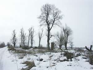 The Mennonite cemetery was established on a square plot surrounded by draining canals, on the southern side of the Węgle - Żurawiec road. Only southern alley of old trees has survived; the main alley has been cut down. Gravestones have been destroyed or stolen. Fragments of tombs, supports in form of tree trunks, a concrete cross from a war-time grave, and a pillar from the entrance gate have survived. The Mennonite cemetery was established on a square plot surrounded by draining canals, on the southern side of the Węgle - Żurawiec road. Only southern alley of old trees has survived; the main alley has been cut down. Gravestones have been destroyed or stolen. Fragments of tombs, supports in form of tree trunks, a concrete cross from a war-time grave, and a pillar from the entrance gate have survived.
Lipińska, t.III, poz. 132, 137; AG, BF.
|
)