|
gm. Nowy Dwór Gdański, pow. nowodworski, woj. pomorskie
Until 1945 Zeyervorderkampen TK (Schrötter)
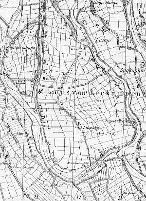
The village was established in the late colonization period that started after 1700 and lasted until the end of the 19th century. In 1820, the village had 258 residents, including 104 Mennonites. The 1868 petition was signed by a merchant from Kępki, J. Dyck. Village layout - flood bank Waldhufendorf type village located on eastern and northern sides of the Nogat (called Kabbelwasser until 1945) and on the western side of the canal Cieplicówka (called Biberzug until 1945) with single-homestead colonies. The cultural landscape is in good condition. Longitudinal and angular homesteads with partially replaced outbuildings have survived. Many homesteads marked on the map are desolate, but those located near the road are being renovated and rebuilt (especially farming sections). The longitudinal or angular layouts are copied by the modern buildings. There is a Mennonite cemetery in the southern section with a cobble stone road lined with old oaks.
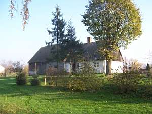 No. 3 is a longitudinal Dutch homestead located on a terpa in
the northern section of the village, on the eastern side of the road
running on the flood bank, facing it with its ridge. The farming section
is higher; the cowshed has been modified (plastered). The home dating from
mid 1900s has a plastered log structure, a vertically boarded gable, a
rafter - collar beam roof structure, and asbestos tile roofing. The
interior has similar bays with the large room in the southwestern corner
and a centrally located black kitchen. The gable elevation has been
modified. It has 2 axes and a 1-axial. The western elevation has 4
axes with an entrance in the northern axis. No. 3 is a longitudinal Dutch homestead located on a terpa in
the northern section of the village, on the eastern side of the road
running on the flood bank, facing it with its ridge. The farming section
is higher; the cowshed has been modified (plastered). The home dating from
mid 1900s has a plastered log structure, a vertically boarded gable, a
rafter - collar beam roof structure, and asbestos tile roofing. The
interior has similar bays with the large room in the southwestern corner
and a centrally located black kitchen. The gable elevation has been
modified. It has 2 axes and a 1-axial. The western elevation has 4
axes with an entrance in the northern axis.
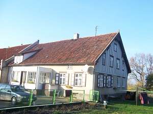 No. 4 is a
longitudinal Dutch homestead situated on a terpa in the northern section
of the village, on the eastern side of the road running on the flood bank,
facing it with its ridge. The farming section (the same height as the
home) is separated from the residential section with a fire wall. The
cowshed has been rebuilt and plastered. The home dates from the 4th
quarter of the 19th century. It has a plastered log structure, vertically
boarded pointing sill and gable, a queen post - purling roof structure
with an angle brace, and pantile roofing. The interior has been modified.
The southern elevation has 2 axes, a 4-axial gable, two windows enclosed
by rectangular skylights, and a rectangular skylight above. The western
elevation has 4 axes and an entrance (with a porch) located in the
2nd axis from the south.lt;br> No. 4 is a
longitudinal Dutch homestead situated on a terpa in the northern section
of the village, on the eastern side of the road running on the flood bank,
facing it with its ridge. The farming section (the same height as the
home) is separated from the residential section with a fire wall. The
cowshed has been rebuilt and plastered. The home dates from the 4th
quarter of the 19th century. It has a plastered log structure, vertically
boarded pointing sill and gable, a queen post - purling roof structure
with an angle brace, and pantile roofing. The interior has been modified.
The southern elevation has 2 axes, a 4-axial gable, two windows enclosed
by rectangular skylights, and a rectangular skylight above. The western
elevation has 4 axes and an entrance (with a porch) located in the
2nd axis from the south.lt;br>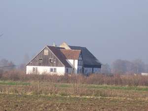 A building without a number is a Dutch
homestead of the longitudinal type located in the colony in the southern
section of the village, on the western side of the local road, facing it
with its ridge. The farming section is separated from the rest by a high
fire wall. The cowshed has a plastered brick ground floor and a wooden
upper section. It has been rebuilt and plastered. The house dates from mid
1900s (plastered). It has a vertically boarded gable, pantile roofing, and
a plastered half-timbered extension (eastern side) supported by a
walled-up arcade. The interior and elevations have been rebuilt. The
southern elevation has 2 axes, a 4-axial gable, two windows enclosed by
rectangular skylights, and a rectangular skylight in the finial. The
eastern elevation has 6 axes, a 3 axial projection in the axes 2-4 from
the south, an entrance in the 3rd axis, and a 2-axial extension with a
preserved timbering in the frontal wall. A building without a number is a Dutch
homestead of the longitudinal type located in the colony in the southern
section of the village, on the western side of the local road, facing it
with its ridge. The farming section is separated from the rest by a high
fire wall. The cowshed has a plastered brick ground floor and a wooden
upper section. It has been rebuilt and plastered. The house dates from mid
1900s (plastered). It has a vertically boarded gable, pantile roofing, and
a plastered half-timbered extension (eastern side) supported by a
walled-up arcade. The interior and elevations have been rebuilt. The
southern elevation has 2 axes, a 4-axial gable, two windows enclosed by
rectangular skylights, and a rectangular skylight in the finial. The
eastern elevation has 6 axes, a 3 axial projection in the axes 2-4 from
the south, an entrance in the 3rd axis, and a 2-axial extension with a
preserved timbering in the frontal wall.
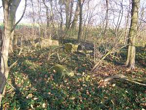 The Mennonite cemetery
was probably established at the beginning of the 19th century. It is
located next to the flood bank, on the northern side of a dirt road, ca.
200 m from farm buildings. Its layout resembles a square (currently, it is
impossible to identify its actual shape). The original layout probably had
one or two sections. The cemetery is severely devastated; the original
trees have been cut down. Single examples of chestnut tree, oak, and
spruce have survived. The graves and gravestones are destroyed. Only
concrete pedestals and bases have remained. There is one overturned cippus
from the 1st half of the 19th century with an illegible inscription and
broken fragments of a ceramic sculpture. Non inscriptions have been
found. The Mennonite cemetery
was probably established at the beginning of the 19th century. It is
located next to the flood bank, on the northern side of a dirt road, ca.
200 m from farm buildings. Its layout resembles a square (currently, it is
impossible to identify its actual shape). The original layout probably had
one or two sections. The cemetery is severely devastated; the original
trees have been cut down. Single examples of chestnut tree, oak, and
spruce have survived. The graves and gravestones are destroyed. Only
concrete pedestals and bases have remained. There is one overturned cippus
from the 1st half of the 19th century with an illegible inscription and
broken fragments of a ceramic sculpture. Non inscriptions have been
found.
Lipińska, t. III, poz. 153 - 154; AG.
|
)