|
gm. Nowy Dwór Gdański, pow. nowodworski, woj. pomorskie
Until 1945 Neustädterwald (Endersch), Schrötter)
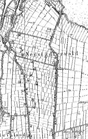
Until the mid 17th century, this area was a part of the Elbląg estate and belonged to the Nowe Miasto (New Town). Originally, it was a forested area, which was systematically cleared since the beginning of the 18th century. The village was established in 1703. The sources from 1776 mentioned the following Mennonite surnames: Born, Coeler, Konrad, Dick, Engbrecht, Ens, Ewenvol, Fast, Friesen, Gebrand, Harder, Jantzen, Klaassen, Krahn, Leben, Neufeld, Nickel, Puls, Siemons, Steingard, Toews, Wirckentin, and Wiebe. In 1820, the village had 433 residents, including 139 Mennonites. Village layout - linear village on terpy located on eastern and western sides of the road that runs northward from the Marzęcino - Nowy Dwór Gdański highway. The cultural landscape of the village is detectable with a field layout and a system of draining canals. The southwestern section of the village has been transformed by buildings of the former state farm. The village has an old Dutch dairy (severely transformed) located in its southern section.
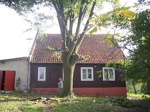 No. 2 is a house from a Dutch homestead of the longitudinal
type. The farming section (demolished) was separated from the house by a
fire wall. The building is located in the southern section of the village,
on the eastern side of the road facing it with its ridge; it dates from
ca. 1897. It is a wooden, vertically boarded building with a high
brick underpinning, a rafter - collar beam roof structure, and pantile
roofing. The gable elevation has 2 axes, a two-level gable with 3 axes on
in the bottom section, and a single window enclosed by two quarter
circular windows. The frontal elevation has 4 axes with an entrance
located in the 3rd axis from the south. No. 2 is a house from a Dutch homestead of the longitudinal
type. The farming section (demolished) was separated from the house by a
fire wall. The building is located in the southern section of the village,
on the eastern side of the road facing it with its ridge; it dates from
ca. 1897. It is a wooden, vertically boarded building with a high
brick underpinning, a rafter - collar beam roof structure, and pantile
roofing. The gable elevation has 2 axes, a two-level gable with 3 axes on
in the bottom section, and a single window enclosed by two quarter
circular windows. The frontal elevation has 4 axes with an entrance
located in the 3rd axis from the south.
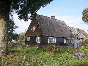 No. 10 is a house from a
Dutch homestead of the longitudinal type (farm buildings have been
transformed) situated on the western side of the road, facing it with its
ridge. It was erected ca. 1860 on a brick underpinning. The building has a
corner-notched structure and is covered by roofing paper; the gable is
vertically boarded. It has a rafter - collar beam roof structure and
asbestos tile roofing. The gable elevation has 2 axes and a single-axis
gable. The frontal elevation has 4 axes with an entrance (with a porch) in
the 2nd axis from the north. No. 10 is a house from a
Dutch homestead of the longitudinal type (farm buildings have been
transformed) situated on the western side of the road, facing it with its
ridge. It was erected ca. 1860 on a brick underpinning. The building has a
corner-notched structure and is covered by roofing paper; the gable is
vertically boarded. It has a rafter - collar beam roof structure and
asbestos tile roofing. The gable elevation has 2 axes and a single-axis
gable. The frontal elevation has 4 axes with an entrance (with a porch) in
the 2nd axis from the north.
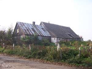 No. 11 is a Dutch homestead of the
longitudinal type situated on the western side of the road, facing it with
its ridge. The homestead dates from ca. 1860. The house is lower than the
cowshed and rests on a brick underpinning. It has a vertically boarded
corner notched structure, a rafter - collar beam roof structure, and sheet
metal roofing (asbestos tile roofing on the cowshed and barn). The gable
elevation has 2 axes and a 3-axial gable (lower section) with a window
enclosed by slotted skylights and similar window above. The frontal
elevation has 4 axes and an entrance located in the 2 axis from the
west. No. 11 is a Dutch homestead of the
longitudinal type situated on the western side of the road, facing it with
its ridge. The homestead dates from ca. 1860. The house is lower than the
cowshed and rests on a brick underpinning. It has a vertically boarded
corner notched structure, a rafter - collar beam roof structure, and sheet
metal roofing (asbestos tile roofing on the cowshed and barn). The gable
elevation has 2 axes and a 3-axial gable (lower section) with a window
enclosed by slotted skylights and similar window above. The frontal
elevation has 4 axes and an entrance located in the 2 axis from the
west.
AG IV, BF, Lipińska, t. III, poz. 150.
|
)