|
gm. Stegna, pow. nowodworski, woj. pomorskie
Until 1945 Schönbaum, Alte Binnerung TK (Gotha, Endersch, Schrötter)

The current village of Drewnica includes the old villages of Drewnica, Drewniczka, and Leszkówki.
In the 2nd half of the 13th century, the area of Drewnica constituted a borderland between the Teutonic Knights' estates and the Pomeranian Duchy. After the eastern Pomerania was conquered by the Teutonic Knights, the order began an intensive colonization campaign, which also involved erection of flood banks. These works were the most intensive between 1325 and ca. 1350. The village of Drewnica was granted the privileges at the beginning of the 2nd half of the 14th century. The village was mentioned in 1359 and its village leader, in 1364. Drewnica was probably a church village established on 54 Chełmno łany. In ca. 1400, the village had 2 mills and 2 inns. In 1454, the village was incorporated into the territories of the city of Gdańsk. In 1627, the Swedish army began to erect fortifications in place of a medieval inn located in to the south of the Vistula fork. Later, the fortifications were taken over by Gdańsk, then re-conquered by Swedes in 1656, and finally besieged, captured, and demolished by the Gdańsk army in 1659. The military activities destroyed the area, including the village. The village was rebuilt by colonists who settled in the region under the emphyteutic contract. In 1771, the village had 21 włókas and 17 morgas of farmland divided among 10 tenants. In its southern section, the village had 12 włókas and 6 morgas of farmland divided among 11 tenants. In 1808, the village had 20 buildings and a mill located in the western section of Schonbaumer Weide; the map shows 4 large homesteads of the longitudinal type and one of the angular type. In 1864, the village of Drewnica had 36 houses and 42 farm buildings, Drewniczka - 17 houses and 27 farm buildings, and Leszkówki - 102 houses. At the end of the 19th century, Drewnica had 414 residents, including 9 Mennonites, while in Drewniczka there were 5 Mennonites among 111 residents. The village layout underwent transformation after digging in the Vistula was completed. 67 houses and two inns were taken down. In 1820, the village had 301 residents, including 11 Mennonites, who belonged to the Żuławki - Niedźwiedzica community. Village layout - the original layout unknown; currently, multi-street village with a cemetery converted into a park in the northeastern section. The cultural landscape is in relatively good condition. The buildings and spatial layout date from the end of the 19th and the beginning of the 20th century. A catalogue from 1979 mentions 46 homesteads of the Dutch type, 78 historical wooden houses: 4 from the first half of the 19th century 51 form the 2nd half of the 19th century, 22 from the beginning of the 20th century, 7 masonry houses, and two windmills. One of the windmills located on a building burnt down in 1990. No arcaded houses have survived. The old houses are being rapidly transformed; the farm buildings are being demolished or all historical materials are being replaced.
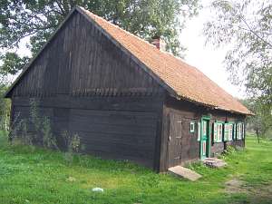 No. 22 is a Dutch homestead of the longitudinal layout
located in the southeastern section of the village on the eastern section
of the local road, facing it with its ridge (common roof). The house has a
corner-notched structure with boarded gables and double pitched roof
covered with pantiles. The gable elevation has 2 axes and a 1-axial gable.
The eastern elevation has 7 axes with entrances on the 1st and 4th
axes from the west. No. 22 is a Dutch homestead of the longitudinal layout
located in the southeastern section of the village on the eastern section
of the local road, facing it with its ridge (common roof). The house has a
corner-notched structure with boarded gables and double pitched roof
covered with pantiles. The gable elevation has 2 axes and a 1-axial gable.
The eastern elevation has 7 axes with entrances on the 1st and 4th
axes from the west.
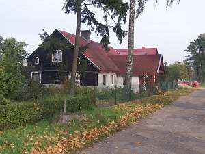 No. 23 is a Dutch homestead of the
longitudinal type situated in the southern section of the village on the
western side of the road, facing it with its ridge. A house and a farm
section (mid 19th century) share the same roof ridge. The house is made of
wood; it has a brick underpinning and a partially plastered corner-notched
log structure. The gable is boarded and a double pitched roof is covered
with sheet metal. The interior has been transformed. The gable elevation
has 2 axes and a two-level gable (3-axial at the bottom) with a window
enclosed by small windows with segmented arches and a semicircular window
above. The eastern elevation has been transformed. No. 23 is a Dutch homestead of the
longitudinal type situated in the southern section of the village on the
western side of the road, facing it with its ridge. A house and a farm
section (mid 19th century) share the same roof ridge. The house is made of
wood; it has a brick underpinning and a partially plastered corner-notched
log structure. The gable is boarded and a double pitched roof is covered
with sheet metal. The interior has been transformed. The gable elevation
has 2 axes and a two-level gable (3-axial at the bottom) with a window
enclosed by small windows with segmented arches and a semicircular window
above. The eastern elevation has been transformed.
 No. 48 is a
house from a Dutch homestead of the angular type (farm building have been
demolished). It dates from the 1894 and is situated in the southeastern
section of the village, on the western side of the local road, facing it
with its ridge (a fire wall on the southern side). Its corner-notched log
structure rests on a brick underpinning. Quoins are covered with board
imitating Tuscan pilaster. The house has a low half-timbered pointing
sill, a boarded gable, and an overhanging corner-notched log attic room in
the eastern slope of the roof. The gable elevation has 3 axes and a
2-axial gable. The southern elevation has 6 axes with an entrance in the
3rd axis from the south. No. 48 is a
house from a Dutch homestead of the angular type (farm building have been
demolished). It dates from the 1894 and is situated in the southeastern
section of the village, on the western side of the local road, facing it
with its ridge (a fire wall on the southern side). Its corner-notched log
structure rests on a brick underpinning. Quoins are covered with board
imitating Tuscan pilaster. The house has a low half-timbered pointing
sill, a boarded gable, and an overhanging corner-notched log attic room in
the eastern slope of the roof. The gable elevation has 3 axes and a
2-axial gable. The southern elevation has 6 axes with an entrance in the
3rd axis from the south.
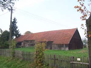
 No. 77 is a Dutch homestead of
the longitudinal type situated in the southern section of the village on
the western side of the local road, facing it with its ridge. The house
dates from the 19th century and is separated from the farm section by a
fire wall. Its plastered wooden structure rests on a brick underpinning.
It has a boarded gable, double pitched roof covered with interlocking
tile. The cowshed has been transformed. No. 77 is a Dutch homestead of
the longitudinal type situated in the southern section of the village on
the western side of the local road, facing it with its ridge. The house
dates from the 19th century and is separated from the farm section by a
fire wall. Its plastered wooden structure rests on a brick underpinning.
It has a boarded gable, double pitched roof covered with interlocking
tile. The cowshed has been transformed.
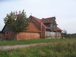
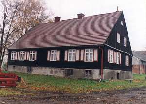
 No. 125 is a Dutch
homestead of the longitudinal type situated in the village center, on the
western side of the local road, facing it with the ridge. All preserved
buildings (a house, a cowshed, and a house) are made of wood. The house
dates from the 3rd quarter of the 19th century and is separated from the
cowshed by a fire wall. Its corner-notched log structure rests on a brick
underpinning. Quoins are covered with board imitating Tuscan pilaster. It
has a boarded gable, a pointing sill, a porch in front of the eastern
entrance, a queen post - purlin roof structure, and a tile roof. The
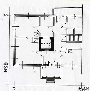
layout has similar bays with the large room located in the eastern bay and
the black kitchen in the large room bay. There is a reversed Z-shaped
bipartite hallway with a row of 4 doors leading to the spaces by the
cowshed wall (with a passage). The gable elevation has 3 axes, a two-level
gable with 3 axes at the bottom a window enclosed by small windows bound
by segmented arches and a semicircular window above. The southern
elevation has 6 axes with an entrance located between half-windows in the
3rd axis from the north. A two-storey cowshed has a vertically boarded
half-timbered structure; its beam-framed ceiling is supported by 2 summer
beams. It has a queen post - purlin roof structure reinforced with angle
braces and covered by a tile roof. The barn has a vertically boarded
half-timbered structure and a tile roof. No. 125 is a Dutch
homestead of the longitudinal type situated in the village center, on the
western side of the local road, facing it with the ridge. All preserved
buildings (a house, a cowshed, and a house) are made of wood. The house
dates from the 3rd quarter of the 19th century and is separated from the
cowshed by a fire wall. Its corner-notched log structure rests on a brick
underpinning. Quoins are covered with board imitating Tuscan pilaster. It
has a boarded gable, a pointing sill, a porch in front of the eastern
entrance, a queen post - purlin roof structure, and a tile roof. The
layout has similar bays with the large room located in the eastern bay and
the black kitchen in the large room bay. There is a reversed Z-shaped
bipartite hallway with a row of 4 doors leading to the spaces by the
cowshed wall (with a passage). The gable elevation has 3 axes, a two-level
gable with 3 axes at the bottom a window enclosed by small windows bound
by segmented arches and a semicircular window above. The southern
elevation has 6 axes with an entrance located between half-windows in the
3rd axis from the north. A two-storey cowshed has a vertically boarded
half-timbered structure; its beam-framed ceiling is supported by 2 summer
beams. It has a queen post - purlin roof structure reinforced with angle
braces and covered by a tile roof. The barn has a vertically boarded
half-timbered structure and a tile roof.
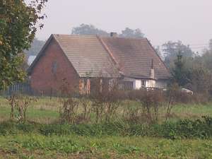
  No. 165 is a house from
1848 located in the colony, in its northern section, on the western side
of a local road, facing it with its ridge. Its corner-notched log
structure rests on a concreted underpinning. Quoins are covered by boards
imitating rustication. It has half-timbered gables, a queen post - purlin
roof structure, and pantile roofing. The interior has a two-bay layout
with the large room in the southwestern corner, and a centrally located
black kitchen. The gable elevation has 3 axes and a 2-axial gable with a
semicircular window located above. The southern elevation was transformed,
and currently has 6 axes; the entrance was liquidated. No. 165 is a house from
1848 located in the colony, in its northern section, on the western side
of a local road, facing it with its ridge. Its corner-notched log
structure rests on a concreted underpinning. Quoins are covered by boards
imitating rustication. It has half-timbered gables, a queen post - purlin
roof structure, and pantile roofing. The interior has a two-bay layout
with the large room in the southwestern corner, and a centrally located
black kitchen. The gable elevation has 3 axes and a 2-axial gable with a
semicircular window located above. The southern elevation was transformed,
and currently has 6 axes; the entrance was liquidated.
Lipińska, t. III, poz. 236
|
)