|
gm. Gronowo Elbląskie, pow. elbląski, woj. warmińsko - mazurskie
Until 1945 Schwarzdamm, TK (Schrötter) Schwartz Tamer(Endersch)
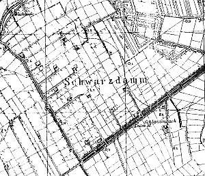
The village was established in 1600. It was a part of the Elbląg estate. The sources from the 4th quarter of the 18th century sources mentioned Peter Albrecht (and possibly also Martin Penner and Johann Wiebe). In 1885, the village had 220 ha, 18 houses, and 103 residents. Village layout - colonial village on terpy located on the northern side of the Jegłownik-Dąbrowo road; enclosed from the west by a road running on a causeway from Nogat flood bank to the Elbląg - Malbork road. Until 1945, there were was a colony of ca. 15 homesteads situated among dense network of polders. The cultural landscape includes: detectable terpy, draining canals, and polders. In 1980s, the historical objects included 4-5 preserved homesteads (out of 19). Currently, the buildings are in fragments (severely transformed).
SGKP, t. X, s. 398; Piątkowski, s.24, Mamuszka, s.95; AGIII, BF, Lipińska, t.III, poz.75.
|
)