|
gm. Stegna, pow. nowodworski, woj. pomorskie
Until 1945 Junkertroyl TK (Schrötter)
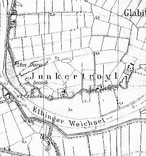
Ca. 1650, an intensive colonization began in the Chorążówka region. In 1820, the village had 168 residents, including 11 Mennonites. The Junkertroylhof estate was developed from a 19th century Dutch farm. Village layout - flood bank Waldhufendorf type village located on terpy on the northern bank of the Vistula Szkarpawa. The cultural landscape is in decline. Several historical houses from the end of the 19th and beginning of the 20th centuries and 2-3 Dutch homesteads have survived. Remains of numerous homesteads (without buildings) on terpy are detectable. The field layout has been partially transformed. A fragment of a linden tree avenue has survived in the eastern section of the village.
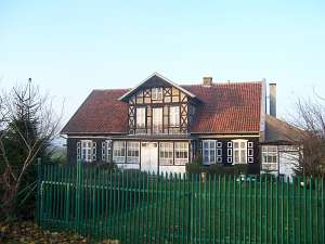 No. 6 is a house from a Dutch homestead of the longitudinal
type (farming buildings have been demolished). It was erected the mid 19th
century and rebuilt in the 4th quarter of the 19th century. It is
located in the central section of the village, on the northern side of a
road that runs on the flood bank, facing it with its ridge. It has a brick
underpinning, a corner-notched log structure with covered quoins, a
boarded gable, a queen post - purlin roof structure, tile roofing, and a
half-timbered attic room in the southern slope of the roof. The gable
elevation has 4 axes with a 4-axial gable two windows enclosed by
quarter-circular small windows and a narrow double window in the finial
enclosed by triangular shapes. The southern elevation is symmetrical with
7 axes and a centrally located entrance with a wide porch. A 3-window
attic room with decorative beams is located above the
entrance. No. 6 is a house from a Dutch homestead of the longitudinal
type (farming buildings have been demolished). It was erected the mid 19th
century and rebuilt in the 4th quarter of the 19th century. It is
located in the central section of the village, on the northern side of a
road that runs on the flood bank, facing it with its ridge. It has a brick
underpinning, a corner-notched log structure with covered quoins, a
boarded gable, a queen post - purlin roof structure, tile roofing, and a
half-timbered attic room in the southern slope of the roof. The gable
elevation has 4 axes with a 4-axial gable two windows enclosed by
quarter-circular small windows and a narrow double window in the finial
enclosed by triangular shapes. The southern elevation is symmetrical with
7 axes and a centrally located entrance with a wide porch. A 3-window
attic room with decorative beams is located above the
entrance.
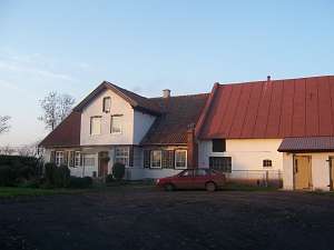 No. 7 is a Dutch homestead of the angular type
(formerly cross-shaped) located in the western section of the village, on
the northern side of the road (facing in with its ridge) that runs on the
flood bank. The house is separated by a fire wall. It dates from mid 19th
century and until 1945 belonged to Otto Lepp. The building has a log
structure, a brick underpinning, a half-timbered extension supported by 4
columns, and sheet metal roofing. It has been insulated with Styrofoam and
plastered. The old windows have been replaced with modern PCV windows. The
arcade has been built in. The cowshed dates from 1936; it has been
transformed and plastered. There is a wooden granary from 1919 in the
southern side of the yard. No. 7 is a Dutch homestead of the angular type
(formerly cross-shaped) located in the western section of the village, on
the northern side of the road (facing in with its ridge) that runs on the
flood bank. The house is separated by a fire wall. It dates from mid 19th
century and until 1945 belonged to Otto Lepp. The building has a log
structure, a brick underpinning, a half-timbered extension supported by 4
columns, and sheet metal roofing. It has been insulated with Styrofoam and
plastered. The old windows have been replaced with modern PCV windows. The
arcade has been built in. The cowshed dates from 1936; it has been
transformed and plastered. There is a wooden granary from 1919 in the
southern side of the yard.
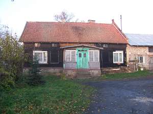 No. 10 is a house from a Dutch
homestead of the angular type (farm building have been demolished). It
dates from the 3rd quarter of the 19th century. It is located in the
western section of the village, on the eastern side of the local road,
facing it with its gable. The eastern fire wall has been preserved. The
building has a corner-notched log structure with quoins covered by boards,
a low, horizontally boarded half-timbered pointing-sill, a vertically
boarded gable, a queen post - purlin roof structure, and pantile roofing.
The bottom section of the western elevation has been transformed. The
gable has 4 axes, two windows enclosed by small rectangular windows, and a
small square window above. The southern elevation (transformed) currently
has 3 axes and a centrally located entrance with a porch. No. 10 is a house from a Dutch
homestead of the angular type (farm building have been demolished). It
dates from the 3rd quarter of the 19th century. It is located in the
western section of the village, on the eastern side of the local road,
facing it with its gable. The eastern fire wall has been preserved. The
building has a corner-notched log structure with quoins covered by boards,
a low, horizontally boarded half-timbered pointing-sill, a vertically
boarded gable, a queen post - purlin roof structure, and pantile roofing.
The bottom section of the western elevation has been transformed. The
gable has 4 axes, two windows enclosed by small rectangular windows, and a
small square window above. The southern elevation (transformed) currently
has 3 axes and a centrally located entrance with a porch.
Lipińska, t. III, poz. 235; AG.
|
)