|
gm. Gąbin, pow. płocki, woj. mazowieckie
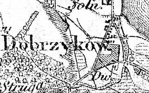
The first mention of the village dates from 1341. In 1827 the village had 28 houses and 458 residents. In 1881 the village had 48 houses and 139 morga of arable land. The Dutch settlers colonized part of the area located by the Vistula river in the second half of the 18th century.
Dobrzyków is a linear village located at the intersection of the roads (from Gąbino and Iłowo) to Płock and Włocławek The fragment of the village that was colonized by the Dutch is located in the northeastern section of the village towards Nowy Troszyn, between the road and the flood-bank. Three homesteads are located on the southern side of the road that runs on the flood-bank. They can be reached by metalled roads that lead southward, all the way, to the wide drainage canal that collects water from the entire floodplain that stretches from Dobrzykowo to Nowe Życko and Świniary.
The cultural landscape is well preserved with a detectable field layout and planted vegetation. The homesteads were erected during the post-war period - no historical objects associated with the colonists.
SGKP, t. II, 1881, s. 86.
|
)