|
gm. Gąbin, pow. płocki, woj. mazowieckie
The village of Czermno was founded under German law in 1494. In the 16th century, the village belonged to the royal estate. The settlement of Holendry Czermińskie was a part Czermno and was founded in 1781 by the Czermno's landowner Kajetan Dembowski on wastelands situated in the lower section of the village.
The landlord gradually imported a group of 17 Olęder settlers in three groups. They were granted considerable amount of land and numerous privileges. Apart from 2 days of corvée labor per year per one włóka, the colonists were exempt from all obligations for 7 years. They also were allowed to use timber to build their houses free of charge. After the period of wolnizna (rent free period) each settler was to pay 2 Polish złote per morga on the St. Martin's day and pay yearly 4 days in corvée labor on horseback and 4 days on foot per each cultivated włóka. The settlers were also to comply with the propination law. They were obliged to buy beverages only in the Holendry Czerwińskie inn.
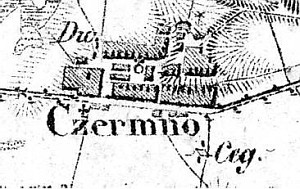
The village had its own court; its composition (sołtys and two jurors) was confirmed every year by Kajetan Dembowski. The landlord also granted the settlers 3 morga of rent and corvée free land to build a school. The colonists were responsible for all costs associated with land reclamation. Every settler was allowed to sell the homestead including the land, but was obliged to pay 2% of the sale price to the manor. Czermno is a linear village located on the northern and southern sides of the Wymyśl Polski - Gąbino road above the floodplain on an embankment of the Vistula's old river bed. The northeastern section of the village, which initially was settled by the Dutch, is located below the embankment perpendicularly to the Słubice - Dobrzyków road.
The buildings are modern and are situated on the northern side of the village road. The cultural landscape has been transformed; however, it is still detectable - a field layout, roadsides planted with willows, and drainage canals.
Dzieje Gostynina...;
Lustracja, s. 235;
SGKP, t. I, 1880, s. 811.
|
)