|
gm. Elbląg, pow. elbląski, woj. warmińsko - mazurskie
Until 1945 Zeyernirderkampen TK (, Schrőtter),
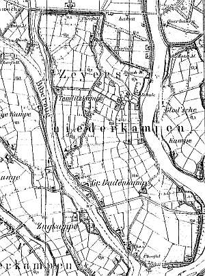
The village was established in 1787. In 1820, it had 172 residents, including 15 Mennonites. In 1919, the village had 512 ha of land and 436 residents. Village layout - flood bank row village located on the eastern side of the Nogat. The cultural landscape is in decline. Spatial layout with homesteads, terpy, and field system is detectable. Historical buildings are disappearing. In 1980s, surveyors identified 14 - 16 historical buildings. Currently there are ca. 8 Dutch homesteads of the longitudinal type and 2 of the angular type with partially replaced buildings. Five wooden houses from 3-4th quarter of the 19th century and several brick buildings from the beginning of the 20th century have survived. .
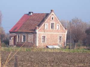 No. 7 is a house from a Dutch homestead from the beginning of
the 20th century. It is made of brick (farming section demolished) and is
situated in the colony on the northern side of the road to Nowakowo. The
building has a brick foundation, a queen post - purlin roof structure,
pantile and sheet metal roofing, and brick walls with a meticulous form
and plastered corners, cornices, and window and door frames. The gable
elevation has 2 axes and a two-axial gable with a window enclosed by two
blind windows in the lower section. The western elevation. has 34 axes
with an entrance in the northern axis. No. 7 is a house from a Dutch homestead from the beginning of
the 20th century. It is made of brick (farming section demolished) and is
situated in the colony on the northern side of the road to Nowakowo. The
building has a brick foundation, a queen post - purlin roof structure,
pantile and sheet metal roofing, and brick walls with a meticulous form
and plastered corners, cornices, and window and door frames. The gable
elevation has 2 axes and a two-axial gable with a window enclosed by two
blind windows in the lower section. The western elevation. has 34 axes
with an entrance in the northern axis.
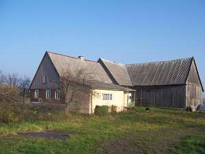
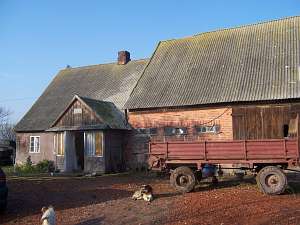 No. 5 is a Dutch homestead
of the longitudinal type situated on the northern side of the road to
Nowakowo, facing it with its ridge (the house on the western side). The
farming buildings are higher and date from the 1930s. The whole structure
is covered with asbestos tiles. The home dates from mid 1800s and has a
brick foundation and a corner-notched, vertically boarded log structure.
It has been modified. The gable elevation has 1 axis, a two-level gable,
two windows in the lower level, and a single window above. The southern
elevation has 3 axes with an entrance and a porch in the eastern
axis. No. 5 is a Dutch homestead
of the longitudinal type situated on the northern side of the road to
Nowakowo, facing it with its ridge (the house on the western side). The
farming buildings are higher and date from the 1930s. The whole structure
is covered with asbestos tiles. The home dates from mid 1800s and has a
brick foundation and a corner-notched, vertically boarded log structure.
It has been modified. The gable elevation has 1 axis, a two-level gable,
two windows in the lower level, and a single window above. The southern
elevation has 3 axes with an entrance and a porch in the eastern
axis.
 A building without a number is a Dutch homestead of the
angular type situated by the Nogat flood bank, on the northern side of the
road running on the flood bank, facing it with its gable. The buildings
have been completely transformed, but retained their original layout. The
old walls were replaced with new material. The original house dates from
the mid 1800s, but it was so severely transformed that its shape resembles
a modern building. A building without a number is a Dutch homestead of the
angular type situated by the Nogat flood bank, on the northern side of the
road running on the flood bank, facing it with its gable. The buildings
have been completely transformed, but retained their original layout. The
old walls were replaced with new material. The original house dates from
the mid 1800s, but it was so severely transformed that its shape resembles
a modern building.
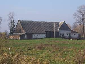
 A building without a number is a Dutch
homestead of the angular type situated in the northern section of the
village on a terpa, facing the Nogat flood bank with its gable. The
farming buildings are higher. The whole structure is covered by asbestos
tiles. The home dates from mid 1900s. It has a stone-brick foundation and
a vertically boarded log structure. The gable elevation has 3 axes with a
single window. The southern elevation has 6 axes with an entrance in the
3rd axis from the east. The cowshed has a partially brick (bottom) and
partially half-timbered (top), vertically boarded structure. A building without a number is a Dutch
homestead of the angular type situated in the northern section of the
village on a terpa, facing the Nogat flood bank with its gable. The
farming buildings are higher. The whole structure is covered by asbestos
tiles. The home dates from mid 1900s. It has a stone-brick foundation and
a vertically boarded log structure. The gable elevation has 3 axes with a
single window. The southern elevation has 6 axes with an entrance in the
3rd axis from the east. The cowshed has a partially brick (bottom) and
partially half-timbered (top), vertically boarded structure.
Kerstan, s. 209 -211; Piątkowski, Lipińska, t. III, poz. 64; AG,
|
)